A selection of the best photos of New Zealand.

Photos about: Trek.
Looking for inspiration?
Don't hesitate to contact a Frogger Guide to ask your questions.
Watch the photos
×
- 55 photos

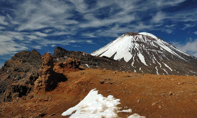
- Tongariro Crossing
Enlarge picture
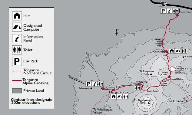
How far does the trek go?
- Tongariro Crossing
The hiking map shows the route from the Mangatepopo car park to the Ketetahi car park.
Enlarge picture

- Tongariro Crossing
Enlarge picture

Is the hike open to beginners?
- Tongariro Crossing
Beginner hikers can perfectly engage on the track. But those among you who do not practice a physical activity regularly should pass their turn or test their condition before coming.
Enlarge picture

What is the easiest part of the trek?
- Tongariro Crossing
As soon as Lake Rotoaira is in sight, you can consider that the rest of the hike will be gently sloping until the finish.
Enlarge picture

Can the trail be used in winter?
- Tongariro Crossing
The hike can be done in winter, but only in the company of a mountain guide. It will be necessary to wear crampons for certain stages. I went through the trek on the first day of spring when there was snow remaining, and the difficulty was much greater than in summer.
Enlarge picture
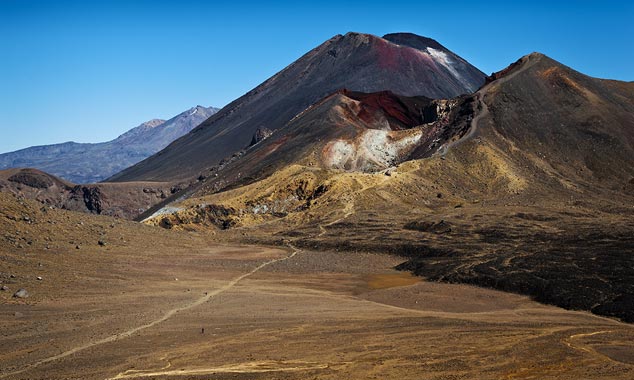
How does the crossing of the central crater take place?
- Tongariro Crossing
Whether in summer or winter (when it is covered by snow), the crossing of the central crater presents no difficulty. You just have to go straight to the blue lake.
Enlarge picture

How is the descent to Ketetahi Hut?
- Tongariro Crossing
The descent towards Ketetahi Hut takes place in the middle of wind-swept yellow tussocks. With the view of Lake Rotoaira, this is one of the easiest and most enjoyable moments of the journey.
Enlarge picture

How should one manage its effort?
- Tongariro Crossing
There is often a tendency to try to mimic the speed of the others. But it is better to listen to your body. Of course, you should not arrive too late. Read the advice of Ben The Kiwi before leaving.
Enlarge picture

Will you have the strength to finish the hike?
- Tongariro Crossing
You are probably able to walk exceptionally five or six hours. But will you have the energy to renew this effort for several days? You need to know your athletic abilities before the start.
Enlarge picture

Is the beginning of the road difficult?
- Tongariro Crossing
The start of the hike is easy, but it can get very cool in the morning, especially in the spring. Start slowly to conserve your strength during the next ascension phase.
Enlarge picture

What is the advantage of following this hike?
- Tongariro Crossing
If the Tongariro is a physical experience, it is above all a succession of breathtaking panoramas. Every effort is largely paid back.
Enlarge picture
Should we fear the volcanic eruptions?
- Tongariro Crossing
Some volcanoes in the North Island are still active and may erupt. Vulcanologists measure risks to protect the population.
Enlarge picture

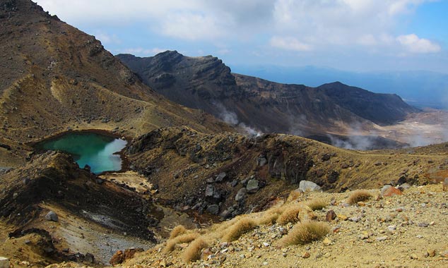
Where are the turquoise lakes in the itinerary?
- Tongariro Crossing
The turquoise lakes are located in the central crater. You will be able to see them when you reach the top of the hike.
Enlarge picture

The Milford Track and the epic landscapes of New Zealand.
- Milford Track
The Milford Track has been attracting visitors from around the world for more than a century, and its ranking of the world's most beautiful hike has remained unchanged since the trail was created.
Enlarge picture

Do you have the hiking gear you need?
- Tongariro Crossing
It is imperative that you try your hiking equipment before departure to ensure it does not obstruct the walk and allows you to hold the distance. Once engaged in a great hike in New Zealand, it will be too late to change shoes!
Enlarge picture

What is the origin of the turquoise lakes?
- Tongariro Crossing
The lakes were formed by volcanic eruptions. Covered with ice in winter, they turn out in early spring.
Enlarge picture
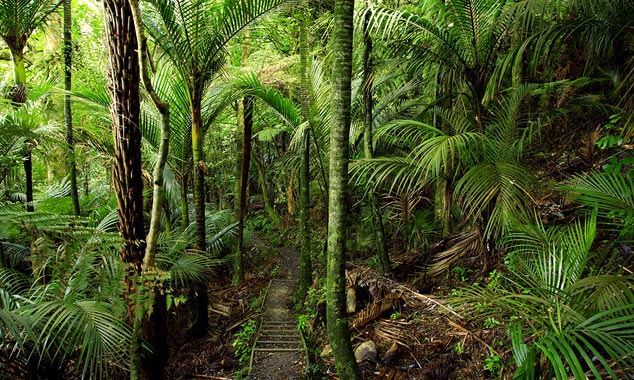
What is the advantage of finishing the trek in the forest?
- Tongariro Crossing
Crossing the forest is the final step. This should be the most pleasant, as the freshness soothes after a day of walking exposed to the sun. But the fatigue accumulated generally prevents you from fully enjoying this part.
Enlarge picture

What is the hardest part of the hike?
- Tongariro Crossing
The climbing phase of Devil's staircase is difficult because the slope is quite steep. But the real difficulty lies in the fact that the passengers advance in single file, which makes it impossible to adjust the pace easily.
Enlarge picture

Can the Ketetahi hot springs be observed?
- Tongariro Crossing
Ketetahi's hot springs are located on sacred ground, it is not allowed to approach them. In fact, all this part of the journey takes place on Maori territory, whose access is only tolerated.
Enlarge picture

What color are the lakes of Tongariro Crossing?
- Tongariro Crossing
Tongariro Crossing hikers will be rewarded for their efforts with the beauty of the turquoise lakes of the central crater and then the blue lake midway.
Enlarge picture

Is the water in the turquoise lakes drinkable?
- Tongariro Crossing
The water of the turquoise lakes is not drinkable. It smokes slightly due to volcanic activity. Impossible to bathe here, of course.
Enlarge picture

What attitude to adopt for hiking?
- Milford Track
The hiking trails are very well maintained by volunteers from the Department of Conservation (DOC). This is not a sufficient reason for departing from all prudence. Plan your itinerary carefully and carry more supplies than necessary.
Enlarge picture

What is the most beautiful hike in the country?
- Tongariro Crossing
It's vety difficult to determine New Zealand's most beautiful hike. But if only one-day walks are taken into account, then the Tongariro Crossing deserves the palm.
Enlarge picture

What is the main highlight of hiking in New Zealand?
- Kepler Track
While it is relatively easy to get caught in a stop in New Zealand (kiwifruit often stops), it is sometimes necessary to wait more than two hours in the deserted areas of South Island. Provide camping equipment in case of problem is recommended.
Enlarge picture

What types of landscapes at Tongariro Crossing?
- Tongariro Crossing
The great strength of Tongariro Crossing is to offer a wide variety of landscapes. The start of the route takes place in an ancient lava field, then the ascent of the volcano reveals turquoise lakes, and the descent on the other slope ends in a magnificent forest.
Enlarge picture

Are there other hikes in Tongariro Park?
- Tongariro Crossing
The Tongariro is the most famous hiking in this National Park. For more information, please contact an iSite in the area.
Enlarge picture

How to explain the red color of the crater?
- Tongariro Crossing
The spectacular red color of the crater is linked to the presence of iron oxide. It results from volcanic activity, and is also found on White Island.
Enlarge picture

What are the safety instructions to observe near the crater?
- Tongariro Crossing
There are no safety gates, so keep your distance with the crater. Do not put yourself in great danger for a simple photo among thousands.
Enlarge picture
How to climb Devil's Staircase without getting exhausted?
- Tongariro Crossing
To climb Devil's Staircase more easily, there is no magical recipe. It is necessary to take breaks, to avoid speaking while walking, and especially to use walking sticks.
Enlarge picture
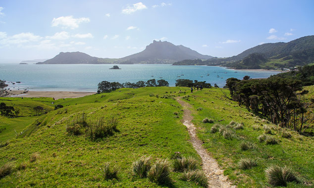
The Smugglers Loop Track.
- Whangarei
As the name suggests, the Smugglers Loop Track returns to its starting point. The 45 minute walk is not difficult and the setting is absolutely wonderful!
Enlarge picture
Where is the arrival point of the hike?
- Tongariro Crossing
The Ketetahi car park marks the end of the hike. There is a shelter, but you can also stretch out in the grass until the shuttle picks you up. An expectation that will be more or less long according to your advance.
Enlarge picture

Is the Tongariro Crossing hiking a paying activity?
- Tongariro Crossing
If the hike is free, the Tongariro Alpine Crossing route does not follow a loop. In other words, it will be necessary that a shuttle comes at the arrival and repatriates you at the end of the day. The ride will cost you a minimum of $ 20 per participant.
Enlarge picture

What is the peculiarity of the South Crater?
- Tongariro Crossing
The South Crater offers a devastating landscape as impressive as it is scary.
Enlarge picture

In which region is the Tongariro Alpine Crossing?
- Tongariro Crossing
The Tongariro Alpine Crossing is located in the heart of a national park ( you will have a glimpse intof it during the shuttle journey to reach the car park of Mangatepopo).
Enlarge picture

How to spot Ketetahi hot springs?
- Tongariro Crossing
You will notice the presence of blocks of sulfur on the edge of the trail. But the rising smoke will immediately inform you of the exact location of the springs.
Enlarge picture

Does the hike give you vertigo?
- Tongariro Crossing
The descent towards the central crater is the most difficult part for visitors who are dizzy. A step that will be much easier if one thinks to bring walking sticks.
Enlarge picture
Where are the shelters located in New Zealand?
- Kepler Track
The long walks, especially those of the Ten Great Walks of the Department of Conservation,last for an average of 3 to 5 days. You can spend the night under the stars in campsites or enjoy refuges (mostly paying).
Enlarge picture

Why do turquoise lakes release steam?
- Tongariro Crossing
The steam that emerges from the turquoise lakes is actually sulfur vapor. Do not forget that you are walking on the side of a volcano that is not extinct.
Enlarge picture

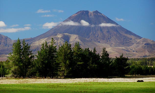
What movie was filmed in the area?
- Tongariro Crossing
With its volcanic landscape, it is quite natural that the Tongariro was chosen to represent the territory of Sauron in the Lord of the Rings of Peter Jackson.
Enlarge picture
How to visit New Zealand despite a low budget?
- Kepler Track
The real disadvantage of the months of April to September is the instability of the weather. However, if you are prepared to withstand lower temperatures and more frequent rain, you can discover the country by taking advantage of significant reductions.
Enlarge picture
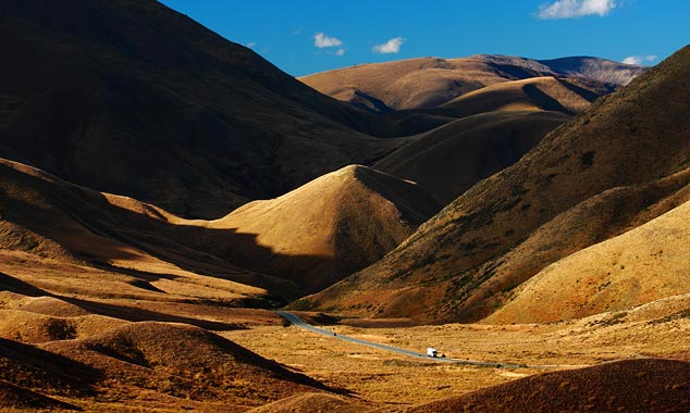
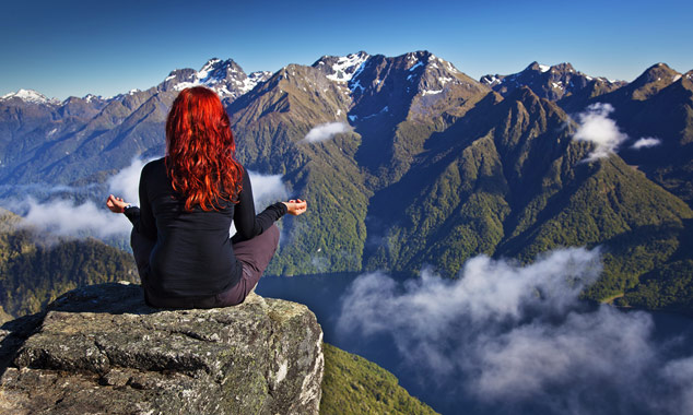
Is nature as beautiful as it is said?
- Lindis Pass
The beauty of the scenery often forces travelers to stop by the roadside. As the country is very sparsely populated, there are no high-voltage lines that could spoil the panorama.
Enlarge picture

What is the name of the lake that can be seen on the other side?
- Tongariro Crossing
Lake Rotoaira (not to be confused with Lake Roturua) is revealed to walkers on the other side of the volcano. It is the return to nature after a long walk on an arid volcanic soil.
Enlarge picture

What is the best time to take pictures?
- Tongariro Crossing
One tends to forget that the Tongariro is located in a national park. I hope you will have the chance to admire the sunset over the valley!
Enlarge picture

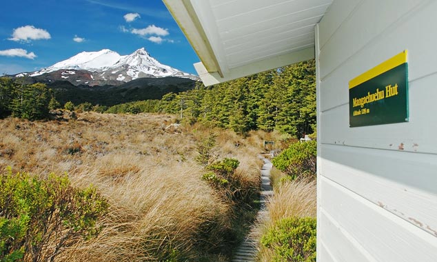
When does the ascension phase begin?
- Tongariro Crossing
Serious things begin at Soda Springs with the first phase of the ascent.
Enlarge picture

Can I plant my tent wherever I want?
- Tongariro Crossing
Freedom camping is legal, but sometimes regulated in tourist places. It is imperative to inquire before camping.
Enlarge picture
Should we absolutely do the Tongariro Alpine Crossing?
- Tongariro Crossing
If the weather does not play tricks and you are in good physical condition, you would be wrong not to follow the Tongariro Crossing. You may be exhausted, but the reputation of the landscapes is not usurped.
Enlarge picture

What kind of vegetation grows on the way?
- Tongariro Crossing
One can practically speak of desert, with a rocky volcanic soil where hardly grow some heather and moss. After all, we must not forget that the area served as a natural setting to represent the Mordor in the Lord of the Rings!
Enlarge picture

Who discovered the blue lake?
- Tongariro Crossing
A Maori explorer discovered this lake in 1750. Its sacred character (tapu) implies some rules like not eating nearby.
Enlarge picture
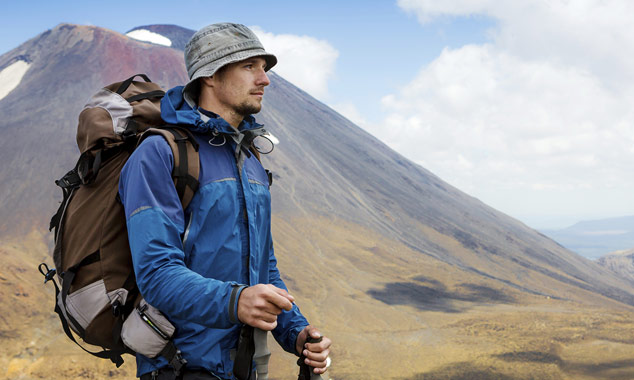
Is your hiking equipment complete?
- Tongariro Crossing
If you do not have the experience of hiking, it is better to seek advice in a specialized shop rather than to find yourself helpless once arrived in New Zealand.
Enlarge picture
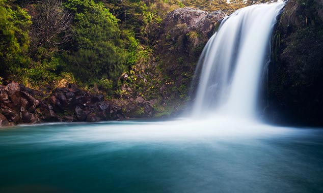
Where is the Ketetahi waterfall?
- Tongariro Crossing
Most hikers are unaware of the Ketetahi waterfall. You have to follow a short optional hike at the end of your itinerary, when you are exhausted. In this state, people generally preferred to lie down in the grass to await the return shuttle.
Enlarge picture

What is the average length of a great hike?
- Routeburn Track
Hiking is not a race against time and you are not here to establish records. Take breaks, admire the landscape and give way to people walking faster than you on the trail.
Enlarge picture

In the heart of the Fiordland forests.
- Milford Track
A bad fall is always possible, especially if you deviate from the trail to venture into the rivers. A simple sprain can end your stay, so be careful.
Enlarge picture

Reviews of Routeburn Track
- Routeburn Track
The Routeburn Track allows you to reach Milford Sound by crossing the mountains. But keep in mind that this 2-3 day hike is not a loop!
Enlarge picture
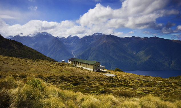
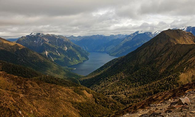
Why should I follow the Kepler Track?
- Kepler Track
The Kepler Track was created especially for trekkers who wanted an alternative to the Milford Track. The starting point is set at Te Anau and the hike loops through Mount Luxmore which culminates at 1400 meters above sea level.
Enlarge picture
55 photos
Remember that these images are not copyright free. You may not reproduce images without permission by Frogger, even for non-commercial use.
- The whole country
- North Island
- South Island
- All locations
- Abel Tasman
- Akaroa
- Auckland
- Bay of Islands
- Cape Reinga
- Cathedral Cove
- Doubtful Sound
- Dunedin
- Fox Glacier
- Hobbiton
- Hot Water Beach
- Huka Falls
- Kaikoura Peninsula
- Lake Matheson
- Milford Sound
- Moeraki Boulders
- Mount Cook
- Pancake Rocks
- Queenstown
- Rotorua
- Tongariro Crossing
- Waitomo Caves
- Wanaka
- Wellington
- White Island


